Skillnad mellan versioner av "Grove - GPS"
| Rad 204: | Rad 204: | ||
[[Category:Grove]] | [[Category:Grove]] | ||
| + | [[Category:Kna-Wiki]] | ||
Versionen från 3 februari 2021 kl. 15.17
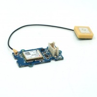
GPS-modulen är en kostnadseffektiv och fältprogrammerbar gadget som är beväpnad med en SIM28 (u-blox 6 är den gamla versionen) och seriell kommunikationskonfiguration. Den har 22 tracking / 66 förvärvskanaler GPS-mottagare. Känsligheten för spårning och förvärv uppnår båda upp till -160dBm vilket gör det till ett utmärkt val för personliga navigationsprojekt och platstjänster samt enastående bland produkter av samma prisklass.
Innehåll
Kompatibilitet
- Arduino
- Raspberry Pi
Port
- Digital (Arduino)
- RPISER (Raspberry Pi)
Mjukvara
U-center: https://www.u-blox.com/en/product/u-center-windows
Exempelkod
Arduino
#include <SoftwareSerial.h>
SoftwareSerial SoftSerial(2, 3);
unsigned char buffer[64];                   // buffer array for data receive over serial port
int count=0;                                // counter for buffer array
void setup()
{
    SoftSerial.begin(9600);                 // the SoftSerial baud rate
    Serial.begin(9600);                     // the Serial port of Arduino baud rate.
}

void loop()
{
    if (SoftSerial.available())                     // if date is coming from software serial port ==> data is coming from SoftSerial shield
    {
        while(SoftSerial.available())               // reading data into char array
        {
            buffer[count++]=SoftSerial.read();      // writing data into array
            if(count == 64)break;
        }
        Serial.write(buffer,count);                 // if no data transmission ends, write buffer to hardware serial port
        clearBufferArray();                         // call clearBufferArray function to clear the stored data from the array
        count = 0;                                  // set counter of while loop to zero
    }
    if (Serial.available())                 // if data is available on hardware serial port ==> data is coming from PC or notebook
    SoftSerial.write(Serial.read());        // write it to the SoftSerial shield
}


void clearBufferArray()                     // function to clear buffer array
{
    for (int i=0; i<count;i++)
    {
        buffer[i]=NULL;
    }                      // clear all index of array with command NULL
}
Raspberry Pi
import serial, time
import smbus
import math
import RPi.GPIO as GPIO
import struct
import sys
#import ir_receiver_check

enable_debug=1
enable_save_to_file=0

#if ir_receiver_check.check_ir():
#   print("Disable IR receiver before continuing")
#   exit()

ser = serial.Serial('/dev/ttyAMA0',  9600, timeout = 0) #Open the serial port at 9600 baud
ser.flush()

def cleanstr(in_str):
    out_str = "".join([c for c in in_str if c in "0123456789.-" ])
    if len(out_str)==0:
        out_str = "-1"
    return out_str

def safefloat(in_str):
    try:
        out_str = float(in_str)
    except ValueError:
        out_str = -1.0
    return out_str

class GPS:
    #The GPS module used is a Grove GPS module http://www.seeedstudio.com/depot/Grove-GPS-p-959.html
    inp=[]
    # Refer to SIM28 NMEA spec file http://www.seeedstudio.com/wiki/images/a/a0/SIM28_DATA_File.zip
    GGA=[]


    #Read data from the GPS
    def read(self):
        while True:
            GPS.inp=ser.readline()
            if GPS.inp[:6] =='$GPGGA': # GGA data , packet 1, has all the data we need
                break
            time.sleep(0.1)     #without the cmd program will crash
        try:
            ind=GPS.inp.index('$GPGGA',5,len(GPS.inp))  #Sometimes multiple GPS data packets come into the stream. Take the data only after the last '$GPGGA' is seen
            GPS.inp=GPS.inp[ind:]
        except ValueError:
            print ("")
        GPS.GGA=GPS.inp.split(",")  #Split the stream into individual parts
        return [GPS.GGA]

    #Split the data into individual elements
    def vals(self):
        if enable_debug:
            print(GPS.GGA)

        time=GPS.GGA[1]

        if GPS.GGA[2]=='':  # latitude. Technically a float
            lat =-1.0
        else:
            lat=safefloat(cleanstr(GPS.GGA[2]))

        if GPS.GGA[3]=='':  # this should be either N or S
            lat_ns=""
        else:
            lat_ns=str(GPS.GGA[3])

        if  GPS.GGA[4]=='':  # longitude. Technically a float
            long=-1.0
        else:
            long=safefloat(cleanstr(GPS.GGA[4]))

        if  GPS.GGA[5]=='': # this should be either W or E
            long_ew=""
        else:
            long_ew=str(GPS.GGA[5])

        fix=int(cleanstr(GPS.GGA[6]))
        sats=int(cleanstr(GPS.GGA[7]))

        if  GPS.GGA[9]=='':
            alt=-1.0
        else:
            # change to str instead of float
            # 27"1 seems to be a valid value
            alt=str(GPS.GGA[9])
        return [time,fix,sats,alt,lat,lat_ns,long,long_ew]

    # Convert to decimal degrees
    def decimal_degrees(self, raw_degrees):
        try:
            degrees = float(raw_degrees) // 100
            d = float(raw_degrees) % 100 / 60
            return degrees + d
        except:
            return raw_degrees


if __name__ == "__main__":
    g=GPS()
    if enable_save_to_file:
        f=open("gps_data.csv",'w')  #Open file to log the data
        f.write("name,latitude,longitude\n")    #Write the header to the top of the file
    ind=0
    while True:
        time.sleep(0.01)
        try:
            x=g.read()  #Read from GPS
            [t,fix,sats,alt,lat,lat_ns,longitude,long_ew]=g.vals()  #Get the individial values

            # Convert to decimal degrees
            if lat !=-1.0:
                lat = g.decimal_degrees(safefloat(lat))
                if lat_ns == "S":
                    lat = -lat

            if longitude !=-1.0:
                longitude = g.decimal_degrees(safefloat(longitude))
                if long_ew == "W":
                    longitude = -longitude

            # print ("Time:",t,"Fix status:",fix,"Sats in view:",sats,"Altitude",alt,"Lat:",lat,lat_ns,"Long:",long,long_ew)
            try:
                print("Time\t\t: %s\nFix status\t: %d\nSats in view\t: %d\nAltitude\t: %s\nLat\t\t: %f\nLong\t\t: %f") %(t,fix,sats,alt,lat,longitude)
            except:
                print("Time\t\t: %s\nFix status\t: %s\nSats in view\t: %s\nAltitude\t: %s\nLat\t\t: %s\nLong\t\t: %s") %(t,str(fix),str(sats),str(alt),str(lat),str(longitude))

            s=str(t)+","+str(safefloat(lat)/100)+","+str(safefloat(longitude)/100)+"\n"

            if enable_save_to_file:
                f.write(s)  #Save to file
            time.sleep(2)
        except IndexError:
            print ("Unable to read")
        except KeyboardInterrupt:
            if enable_save_to_file:
                f.close()
            print ("Exiting")
            sys.exit(0)